Home Page    |   Contact Us   
   Custom Mapping Specialists    |    Awards    |    Online Shopping    |    Promotional Map Products   
Home
About Cartodraft

ONLINE SHOPPING

Browse online shop

- Map and Plan Measuring Tools

Delivery and Order Information

CRAIGIES MAPS

- Visitors Maps
- Touring Maps
- State Maps
- Street Directories
- Laminated Maps

WALL MAPS

- Laminated

EDUCATIONAL WALL MAPS

- World Political
- Australia and its Neighbours
- Australia Political
- Australia Physical
- New South Wales

POSTCODE MAPS

- Postcode Maps

CUSTOM MAPPING

- Custom Mapping Services
- Showcase

MAP ENLARGEMENTS

- Mapping Enlargements

WEBSITE MAPPING

- Maps for websites
- Showcase

LAMINATING SERVICE

- Lamination Services

PRINTING SERVICE

- Printing Services

DIGITAL MAPS

- International
- Australian
- New Zealand

GPS

- Hema Navigator

GROOVY MAPS

- Maps & Guides

SATELLITE MAPS AND POSTERS

- Satellite Maps and Posters

TOPOGRAPHIC MAPS

- NSW Lands
- NATMAP 1:50,000
- NATMAP 1:100,000
- NATMAP 1:250,000
- National
- NATMAP PNG
- Raster CD & DVD

MAP AND PLAN MEASURING TOOLS

- Scalex Map Wheel™
- Scalex Plan Wheel™

CARTOGRAPHY BOOKS

- Getting there from Here
- The States of a Nation

PROMOTIONAL PRODUCTS

- Desk Pads, Courtesy maps and more

CD AND DVD PRODUCTS

- Digital Street Directories
- Postcodes Australia and DVD Products
- Topographic Maps and DVD Products
- CD Maps

INTERNATIONAL MAPS

- Countries/Regions A-D
- Countries/Regions E-H
- Countries/Regions I-L
- Countries/Regions M-P
- Countries/Regions S-U
- Groovy Map 'n Guide

STREET DIRECTORIES

- Street Directory -ACT
- Street Directory -NSW
- Street Directory -NT
- Street Directory -QLD
- Street Directory -SA
- Street Directory -VIC
- Street Directory -WA
- Street Directory -NZ

ATLASES AND GUIDES

- Road Atlases
- Touring & Recreational Guides

TOURING MAPS

- City to City Touring Maps

WORLD MAPS

- World Maps

AUSTRALIAN MAPS

- Australian Maps

FORESTRY MAPS

- Forestry Maps - NSW

NATIONAL PARK MAPS

- National Park Maps - NSW
- National Park Maps - Vic
- National Park Maps - Qld
- National Park Maps - Tas

4WD MAPS & GUIDES

- Great Desert Track Series
- 4 Wheel Driving Maps
- 4 Wheel Driving Guides
- 4 Wheel Driving CD's

CITY MAPS

- Major Cities A-B
- Major Cities C-L
- Major Cities M-P
- Major Cities S-Z
- Regional Cities

REGIONAL MAPS

- Regional Maps -NSW
- Regional Maps -NT
- Regional Maps -QLD
- Regional Maps -SA
- Regional Maps -VIC
- Regional Maps -WA
- Regional Maps -TAS

STATE MAPS

- State Maps -NSW
- State Maps -NT
- State Maps -Queensland
- State Maps -SA
- State Maps -Victoria
- State Maps -WA
- State Maps -Tasmania

NEW ZEALAND MAPS

- New Zealand - Atlases
- New Zealand - Maps
- New Zealand - City Maps
- New Zealand - Street Directories
- New Zealand - Regional Maps
- New Zealand - Laminated Maps
Awards
Links
Terms and conditions
Privacy Policy
Information Request/Contact

Map and Plan Measuring Tools - Scalelink Wireless 3 Kit


Map and Plan Measuring Tools > Scalelink Wireless 3 Kit

3 steps to ordering maps from Cartodraft:
  • Enter quantity required next to Qty.
  • Click on the Buy button. Add more products by clicking Continue Shopping button
  • To complete your purchase, click on CHECKOUT button.

Scalelink Wireless 3 Kit
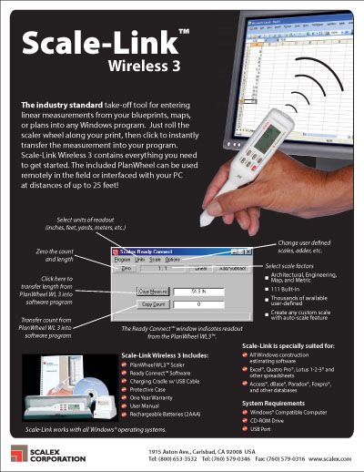
All new version! Interface the PlanWheel with your estimating software without the interference of a cumbersome cable. The Scale-Link Wireless 3 includes the PlanWheel WL3, Charging Cradle with USB Cable, Scalex Ready Connect Software, User?s guide, Rechargeable batteries (2 AAA) and a Protective Case. Scale-Link Wireless 3 is compatible with all Windows construction estimating programs including Microsoft Excel. The industry standard take-off plan measuring wheel tool for entering linear measurements from your blueprints, maps, or plans into any Windows program. Just roll the Scalex plan measuring wheel along your print, then click to instantly transfer the measurement into your program. Scale-Link Wireless 3 contains everything you need to get started. The included PlanWheel can be used remotely in the field or interfaced with your PC at distances of up to 7.5 metres.
The package includes the Planwheel WL3 scaler, Ready Connect-software, Charging Cradle, rechargeable batteries and a Protective case.
Calculate auto-scale factor from reduced, enlarged or odd-scale drawings
Measures in inches, feet, yards, miles, centimeters, and kilometers
Calculates square and cubic dimensions for regular areas and volumes
Counter and adder buttons on probe tip let you count items or add fixed lengths as you scale
Create, store and retrieve 2 user-defined scale factors
Clear, audible tone indicates wheel movement
Automatic shut-off assures long battery life
Low battery indicator
Plus minus (+ -) mode allows user to simply back to deduct an over-rolled measurement
SPW07 $440.00 ea   Qty

Your Basket

0 items in basket


   Copyright Cartodraft P/L 2001-2019   Online map store Contact Cartodraft