|
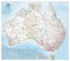
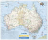
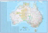
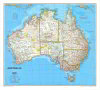
1.
Australia Large
Hema; Scale 1:4,500,000
Size 1000 x 875mm |
|
|
|
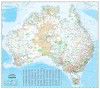
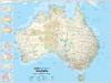
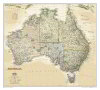
2.
Australia Supermap
Scale 1:3,300,000
Size 1345 x 1180mm |
|
|
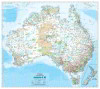
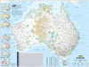
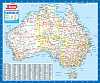
3.
Australia Map
Cartodraft; Australia Map 1241 x 1100(h) mm
Large map of Australia with towns, cities, roads, rivers, highways all clearly displayed with an easy-to-read index of towns |
|
|
|
4.
Australia Reference Map
Cartodraft; Australia Reference Map 1680 x 1480 mm |
|
|
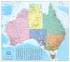
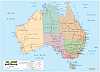
5.
Australia Political Map
Cartodraft; Australia Political Map 1241 x 1100(h) mm
This map clearly displays cities, towns, roads and rail networks with the addition of shading of the states as an easy visual reference. Towns index included. |
|
|
|
6.
Australia Political Reference Map
Cartodraft; Australia Political Reference Map 1680 x 1480 mm
This map clearly displays cities, towns, roads and rail networks with the addition of shading of the states as an easy visual reference. Towns index included. |
|
|
|
7.
Australia Reference Map Large
Cartodraft; Australia Reference Map 2000 x 1780 mm |
|
|
|
8.
Australia Reference Map, Extra Large
Cartodraft; Australia Reference Map, Extra Large size 2400 x 2130 mm |
|
|
|
9.
Australia Mega Map
Hema; Size 1660 x 1460mm |
|
|
10.
Australia and New Zealand
Cartodraft: Australia and New Zealand Map Size: 1000 x 887mm |
|
|
11.
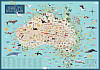
Illustrated Australia
Explore Australia: Showcasing more than 300 illustrations of flora, fauna, landmarks, attractions and other Australiana, the detail on this map could keep anyone enthralled for hours.
Fact bubbles, and keys for shipwrecks and Indigenous rock-art sites, will also help you learn more about this country.
This map is printed on laminated, tearproof, writable and washable high-quality art paper. They are available for individual sale in a nicely designed tube.
Size: 1350mm x 950 |
|
|
12.
Australia 5Million General Reference Map
Scale 1:5,000,000 Size 985 x 840mm
This map is suitable for school, office and home use as a single-sheet wall poster or as a handy reference item. The map includes more than 2000 named features as well as a gazetteer on the back of the map as an aid to locating places of interest. |
|
|
13.
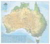
Australia Road and Terrain
Hema; Scale 1:4,500,000
Size 1000 x 875mm |
|
|
|
14.
Australia Road & Terrain Mega Map
Hema: Size: 1686 x 1481 mm. A picturesque map of Australia that is ideal as a wall map for trip planning, decoration and education. Climate zones are coloured to easily show the variances in temperature and rainfall across the country. Full terrain and road map showing major road networks, Outback fuel, distances and major national parks marked, Climate zones, Index, Distance grid. |
|
|
15.
Australia Handy
Hema; Scale: 1:6 500 000 Size: 750 x 615 mm
A map of Australia that shows country?s national parks and major road networks with distances for planning, along with major city CBD maps, a distance chart and a placename index for practical use. |
|
|
16.
Australia Wall Map
Meridian Maps;
Scale 1:4,750,000 Size 1003 x 865mm |
|
|
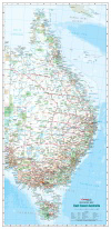
17.
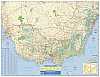
East Coast Australia
Cartodraft; East Coast of Australia Reference Map Size: 680 x 1400mm |
|
|
|
18.
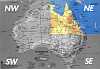
Auslig Wall Map of Australia
Scale 1:2,500,000
Size 1960 x 1680mm (4 sheets)
Geoscience Australia's wall map of Australia is ideal for displays and feature walls in offices, classrooms and conference rooms. |
|
|
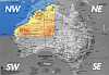
19.
Auslig Australia - NW Quadrant
Scale 1:2,500,000 North West Quadrant of Geoscience Australia`s wall map of Australia
Map measures 1030mm x 880mm. |
|
|
20.
Auslig Australia - NE Quadrant
Scale 1:2,500,000 North East Quadrant of Geoscience Australia`s wall map of Australia
Map measures 1030mm x 880mm. |
|
|
21.
Auslig Australia - SW Quadrant
Scale 1:2,500,000 South West Quadrant of Geoscience Australia`s wall map of Australia
Map measures 1030mm x 880mm. |
|
|
22.
Auslig Australia - SE Quadrant
Scale 1:2,500,000 South East Quadrant of Geoscience Australia`s wall map of Australia
Map measures 1030mm x 880mm. |
|
|
23.
Australia Small
Cartodraft: Size 500 x 415mm
A handy sized map clearly marked with major towns and cities, highways, main roads and railways. Also includes journey times/distance chart and land mass comparison diagrams. |
|
|
24.
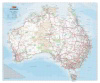
Australia 149
UBD; Size 920 x 675mm, Scale: 1:5 800 000
Published by Gregory's, this Australia 149 map includes National Parks, Aboriginal areas, descriptions of points of interest plus a comprehensive index. |
|
|
25.
Australia 180
UBD; Size 1000 x 690mm, Scale 1:5 800 000
UBD's 180 Road map of Australia. With town, city & locality index, road distances, National Parks and Aboriginal areas. |
|
|
|
26.
Australia Large 180
UBD; Size 1480 x 1020mm
UBD's 180 large road map of Australia. With town, city & locality index, road distances, National Parks and Aboriginal areas. This is a 150% enlargement of the UBD Australia 180 |
|
|
|
27.
Australia Xtra Large 180
UBD; Size 2000 x 1380mm
UBD's 180 extra large road map of Australia. With town, city & locality index, road distances, National Parks and Aboriginal areas. This is a200% enlargement of the UBD Australia 180 |
|
|
28.
Australia Gregorys 1 Sheet 150
UBD; Size 1080 x 810 mm |
|
|
29.
Australia Gregorys 2 Sheet 169
UBD; Size 1360 x 1020 mm |
|
|
30.
Australia and its Neighbours
Scally Gregory's Australia and its Neighbours map. Size; 1280 x 920mm
Ideal for regional studies, countries are coloured and major cities are marked according to population. It focuses on Australia and countries to its north
Flat, laminated version only.
Reverse side includes black line map suitable for use with whiteboard markers and A4 print suitable for classroom copies |
|
|
31.
Australia Political
Scally Gregory's Australia Political map. Size; 1270 x 920mm
A popular map with state boundariesa and states coloured with bold and uncluttered information for educational uses.
Flat, laminated version only. |
|
|
32.
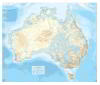
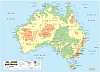
Australia Physical
Scally Gregory's Australia Physical map. Size; 1270 x 920mm
Coloured to simply illustrate Australia's topography the information is presented clearly for educational purposes.
Flat, laminated version only. |
|
|
33.
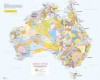
Aboriginal Australia Map (A3)
AIASIS: Laminated Small Wall Map: 420 x 297mm
The highly popular AIATSIS map of Indigenous Australia is now available in a compact, portable A3 size. Its the perfect take-home product for tourists and anyone interested in the diversity of Australia?s first nations peoples. The handy desk size also makes it an ideal resource for individual student use (edited by David Horton) The map represents research carried out for the Encyclopaedia of Aboriginal Australia. The research method was to use the published resources available between 1988 and 1994. The map was then created as a graphic illustration. It indicates only the general location of larger groupings of people, which may include smaller groups such as clans, dialects or individual languages in a group. |
|
|
|
34.
Aboriginal Australia Map (Sml)
AIASIS: Laminated Small Wall Map: 841 x 594mm
The Aboriginal Australia map (edited by David Horton) The map represents research carried out for the Encyclopaedia of Aboriginal Australia. The research method was to use the published resources available between 1988 and 1994. The map was then created as a graphic illustration. It indicates only the general location of larger groupings of people, which may include smaller groups such as clans, dialects or individual languages in a group. |
|
|
|
35.
Aboriginal Australia Map (Lge)
AIASIS: Laminated Large Wall Map:1189 x 841mm
The Aboriginal Australia map (edited by David Horton) The map represents research carried out for the Encyclopaedia of Aboriginal Australia. The research method was to use the published resources available between 1988 and 1994. The map was then created as a graphic illustration. It indicates only the general location of larger groupings of people, which may include smaller groups such as clans, dialects or individual languages in a group. |
|
|
36.
South East Australia Wall Map
Meridian Maps;
Scale 1:1,250,000 Size 1005 x 815mm |
|
|
37.
National Geographic Australia
National Geographic; Scale 1:6 413 000 Size: 770 x 690 mm Tasmania and City maps as inset |
|
|
38.
National Geographic Australia Executive
National Geographic; Scale 1:6 413 000 Size: 770 x 690 mm Tasmania and City maps as inset. Executive style |
|
|
39.
Ausway Australia Wall Map
Ausway: Australia coverage. The map scale is the same as the Green Bordered Australia Map in the Melway/Sydway/Brisway. A town index is listed also. 1000 x 830 mm |
|

