|
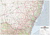
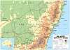
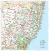
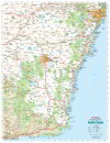
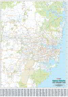
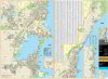
1.
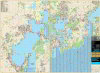
New South Wales
Hema; New South Wales State Map
Scale 1:1,500,000
Size 1000 x 700 mm |
|
|
|
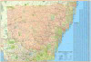
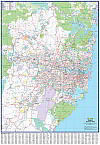
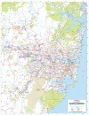
2.
New South Wales Supermap
Hema; Scale 1:1,100,000
Size 1400 x 1000 mm |
|
|
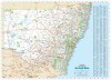
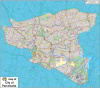
3.
New South Wales
UBD; The New South Wales State Laminated Map 270 has detailed coverage of NSW with a Towns and Localities index. Major and minor roads are shown along with highways, National Parks, nature reserves, and major and minor townships.
The reverse side features a Sydney Suburban map stretching from Gosford to Clifton, and Springwood in the west.
Scale 1:1,600,000
Size 1000 x 690 mm |
|
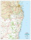
|
|
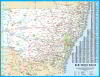
4.
New South Wales Large
UBD; The Large New South Wales State Laminated Map 270 has detailed coverage of NSW with a Towns and Localities index. Major and minor roads are shown along with highways, National Parks, nature reserves, and major and minor townships.
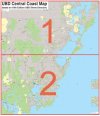
This is a 150% enlargement of the New South Wales State Laminated Map 270
Size 1480 x 1020mm |
|
|
|
5.
New South Wales Xtra Large
UBD; The Large New South Wales State Laminated Map 270 has detailed coverage of NSW with a Towns and Localities index. Major and minor roads are shown along with highways, National Parks, nature reserves, and major and minor townships.
This is a 200% enlargement of the New South Wales State Laminated Map 270
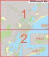
Size 2000 x 1380mm |
|
|
6.
New South Wales State Map
Cartodraft: New South Wales State Map 1000 x 714(h)mm Clearly labelled with an easy-to-read Town Index. Newly updated to include local government area boundaries for the whole of New South Wales. |
|
|
|
7.
New South Wales Reference Map
Cartodraft: New South Wales Reference Map 1400 x 1000mm Clearly labelled with an easy-to-read Town Index. Newly updated to include local government area boundaries for the whole of New South Wales. |
|
|
|
8.
New South Wales Reference Map Large
Cartodraft: New South Wales Reference Map Large 2000 x 1428mm Clearly labelled with an easy-to-read Town Index. Newly updated to include local government area boundaries for the whole of New South Wales. |
|
|
9.
New South Wales Small
Craigies Scale 1:2,545,000
Size 625 x 480mm |
|
|
10.
New South Wales
Scally Gregory's New South Wales map. Size; 1280 x 920mm
Designed for detailed study of the state. A topographical map with all information clearly displayed and easy to read.
Flat, laminated version only. |
|
|
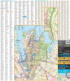
11.
Sydney Business
UBD; A Sydney Suburban map showing postcode numbers and boundaries. The map also shows Local Government Area boundaries and names as well as industrial areas. The metropolitan area is represented featuring main road and suburb names with a full suburb index included.
Scale 1:75,000
Size 1000 x 1480 mm |
|
|
|
12.
Sydney Business Large
UBD; A Sydney Suburban map showing postcode numbers and boundaries. The map also shows Local Government Area boundaries and names as well as industrial areas. The metropolitan area is represented featuring main road and suburb names with a full suburb index included.
This is a 150% enlargement of the UBD Sydney Business map. Size 1480 x 1980 mm |
|
|
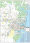
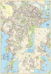
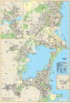
13.
Greater Sydney
Hema; Scale 1:100,000
Size 700 x 1000mm |
|
|
|
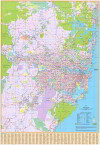
14.
Greater Sydney Supermap
Hema; Scale 1:70,000
Size 1000 x 1400mm |
|
|
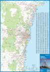
15.
Sydney Suburban
UBD; With coverage from Gosford in the north, Tahmoor in the south and Springwood in the west, and along the coast from Umina Beach in the north to Coalcliff in the south, this map also includes an index to the suburbs and localities. This map has a detailed coverage of the Sydney suburbs.
Scale 1:110,000
Size 690 x 1000mm |
|
|
|
16.
Sydney Suburban Large
UBD; With coverage from Gosford in the north, Tahmoor in the south and Springwood in the west, and along the coast from Umina Beach in the north to Coalcliff in the south, this map also includes an index to the suburbs and localities. This map has a detailed coverage of the Sydney suburbs.
This map is a 150% enlargement of the UBD Sydney Suburban Size 1020 x 1480mm |
|
|
|
17.
Sydney Suburban Xtra Large
UBD; With coverage from Gosford in the north, Tahmoor in the south and Springwood in the west, and along the coast from Umina Beach in the north to Coalcliff in the south, this map also includes an index to the suburbs and localities. This map has a detailed coverage of the Sydney suburbs.
This map is a 200% enlargement of the UBD Sydney Suburban Size 1380 x 2000mm |
|
|
18.
Sydney Industrial
Cartodraft; Size 770 x 1000mm
Sydney suburban map featuring industrial areas, suitable for a wide variety of business uses. |
|
|
|
19.
Sydney Industrial Supermap
Cartodraft; Size 1078 x 1400mm
Large format Sydney suburban map featuring industrial areas, suitable for a wide variety of business uses. |
|
|
20.
Sydney & Environs
Craigies Sydney & Environs is a double sided map with all the latest updates
The Sydney Environs side features all major and secondary roads, with suburbs and towns, national and state route numbers.� Extending from Nelson Bay in the north, Sussex Inlet in the south, to Lithgow in the west it is fully indexed.
On the reverse the Sydney Suburbs side has a full suburban index with postcodes, Industrial areas, national parks and forests. It extends from Brisbane Water in the north, Stanwell Tops in the south, and to Lapstone in the west.
This map is invaluable for anyone wanting to get around the greater Sydney area for business or pleasure.
Environs Scale 1:308 000
Sydney Suburbs Scale 1:98 000
Size 700 x 1000m |
|
|
|
21.
Sydney & Environs Supermap
Craigies;
Size 900 x 1400mm |
|
|
22.
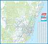
North Coast Reference
Cartodraft; North Coast Reference Map Size: 1000 x 1050mm |
|
|
23.
Far North Coast Reference
Cartodraft; Far North Coast New South Wales Reference Map
Size: 900 x 1165mm
This wall map stretches from Caboolture, QLD in the north to Kempsey, NSW in the south, to Inglewood, QLD and Tamworth, NSW in the west. Its large size and clear labels makes it a useful resource for working in the upper North Coast and border areas of NSW and Queensland |
|
|
24.
South Coast Reference
Cartodraft; South Coast Reference Map Size: 900 x 1165mm |
|
|
25.
Sydney City Pocket
UBD; 650 x 750mm |
|
|
26.
Sydney 6 Sheet
6 Sheet Metropolitan map covering the entire Sydney Metropolitan Area with full street detail
Scale 1:35,000
Size 2060 x 2000 mm |
|
|
|
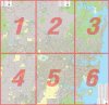
27.
Sydney 6 Sheet (4 Sheet option)
4 Sheet Metropolitan map with fulll street detail, Scale 1:35,000
Customise your map by choosing which part of Sydney you want to focus on
Refer to key map to determine coverage; Size 1390 x 2000mm |
|
|
|
28.
Sydney 6 Sheet (3 Sheet option)
3 Sheet Metropolitan map with fulll street detail, Scale 1:35,000
Refer to key map to determine coverage
Size 2060 x 1010mm |
|
|
|
29.
Sydney 6 Sheet (2 Sht N/S option)
2 Sheet Metropolitan map N/S with fulll street detail, Scale 1:35,000
Refer to key map to determine coverage
Size 705 x 2000mm |
|
|
|
30.
Sydney 6 Sheet (2 Sht E/W option)
2 Sheet Metropolitan map E/W with fulll street detail, Scale 1:35,000
Refer to key map to determine coverage
Size 1390 x 1010mm |
|
|
|
31.
Sydney 6 Sheet (1 Sheet option)
Single Sheet Metropolitan Map with fulll street detail, Scale 1:35,000
Refer to key map to determine coverage
Size 705 x 1010 mm |
|
|
32.
Sydney Wall Map
Ausway; Size: 1055 x 960mm The Sydway wallmap -It covers from Belmont in the north to Picton and Helensburg in the south and in the west to Lithgow |
|
|
33.
Sydney Suburbs Local Government Areas Supermap
Cartodraft
Size 985 x 1400mm The Sydney Suburbs Local Government Area Supermap has a full suburban index with postcodes, and Local Government Area Council boundaries from 2017 highlighted on the map. It extends from Brisbane Water in the north, Stanwell Tops in the south, and to Lapstone in the west.
Its large size and clear labels makes it a useful resource for business applications and the office. |
|
|
34.
City of Parramatta Council LGA Map 1:15K
UBD; Scale of 1:15 000, Size: 960 x 840mm
The City of Parramatta Council Local Government Area (LGA) Map is based on the UBD Gregory's Sydney 2016 Street Directory and the new Parramatta LGA boundary. Symbols such as hospitals, post offices, schools, service stations and shopping centres all appear.
New LGA boundary as proclaimed on 12 May 2016
Latest street detailed map |
|
|
|
35.
City of Parramatta Council LGA Map 1:10K
UBD; Scale of 1:10 000, Size: 1440 x 1260mm
The City of Parramatta Council Local Government Area (LGA) Map is based on the UBD Gregory's Sydney 2016 Street Directory and the new Parramatta LGA boundary. Symbols such as hospitals, post offices, schools, service stations and shopping centres all appear.
New LGA boundary as proclaimed on 12 May 2016
Latest street detailed map |
|
|
36.
Newcastle
UBD; Tourist Map
Size 710 x 1000 mm |
|
|
37.
Newcastle 2 Sheet
Scale 1:30,000
Size 1740 x 2030mm |
|
|
|
38.
Newcastle 2 Sheet (1 Sheet option)
Scale 1:30,000
Size 1740 x 1020mm |
|
|
39.
Wollongong 2 Sheet
Scale 1: 25,000
Size 1320 x 985 mm |
|
|
40.
Wollongong
UBD Size 690 x 1000mm
Laminated wall map of map 299 Wollongong Suburban Streets. Street level mapping and street index at a scale of 1 : 25 000 from Helensburgh in the north to Dunmore in the south. Coverage included for Berry & Nowra, North Nowra & Bomaderry
Index to suburbs & localities
On the reverse is an overview map of Wollongong to Nowra at a scale of 1 : 685 700 |
|
|
41.
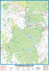
Blue Mountains National Parks
Craigies; Blue Mountains National Park Map covers the Blue Mountains, Kanangra-Boyd and Abercrombie River National Parks extending from Lidsdale in the north to Wombeyan Caves and Bargo in the south.
This very detailed map includes road, highways, road shields, suburbs and towns. Wilderness, forest and water catchment boundaries are also marked along with a handy grid for the 1:25 000 NSW topographic map coverage.
A very useful map for a complete overview of the Blue Mountains region it allows visitors to plan their journeys, with many fire trails and walking routes noted. The reverse side features detailed town maps of Blue Mountains townships including Blackheath, Medlow Bath, Katoomba, Leura, Wentworth Falls, BullaburraHazelbrook, Woodford, Faulconbridge, Springwood, Valley Heights, Warrimoo, Blaxland, Glenbrook, Mount Riverview and Lapstone.
Also included are mud maps for Blackheath, Katoomba, Leura and Wentworth Falls walking tracks noting lookouts, walking times and track grades.
National Parks Map Scale 1:130,000
Size (unfolded) 700 x 1000mm 1000 x 690mm |
|
|
42.
Blue Mountains
Scale 1:35,000
Size 920 x 685 mm |
|
|
43.
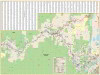
Central Coast UBD Gregorys 289 Street Wall Map
Central Coast Suburban Street Map, 2 sheet E/W
Size 1420 x 1015mm Scale 1:25 000 |
|
|
44.
Central Coast 2 Sheet N/S
2 Sheet Metropolitan map covering the entire Metropolitan Area
Size 1520 x 1760mm |
|

