|
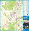
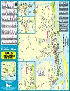
1.
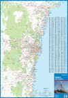
Sydney & Environs
Craigies Sydney & Environs is a double sided map with all the latest updates
The Sydney Environs side features all major and secondary roads, with suburbs and towns, national and state route numbers.ÿ Extending from Nelson Bay in the north, Sussex Inlet in the south, to Lithgow in the west it is fully indexed.
On the reverse the Sydney Suburbs side has a full suburban index with postcodes, Industrial areas, national parks and forests. It extends from Brisbane Water in the north, Stanwell Tops in the south, and to Lapstone in the west.
This map is invaluable for anyone wanting to get around the greater Sydney area for business or pleasure.
Environs Scale 1:308 000
Sydney Suburbs Scale 1:98 000
Size 700 x 1000m |
|
|
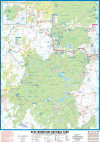
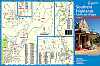
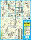
2.
Blue Mountains National Parks
Craigies; Blue Mountains National Park Map covers the Blue Mountains, Kanangra-Boyd and Abercrombie River National Parks extending from Lidsdale in the north to Wombeyan Caves and Bargo in the south.
This very detailed map includes road, highways, road shields, suburbs and towns. Wilderness, forest and water catchment boundaries are also marked along with a handy grid for the 1:25 000 NSW topographic map coverage.
A very useful map for a complete overview of the Blue Mountains region it allows visitors to plan their journeys, with many fire trails and walking routes noted. The reverse side features detailed town maps of Blue Mountains townships including Blackheath, Medlow Bath, Katoomba, Leura, Wentworth Falls, BullaburraHazelbrook, Woodford, Faulconbridge, Springwood, Valley Heights, Warrimoo, Blaxland, Glenbrook, Mount Riverview and Lapstone.
Also included are mud maps for Blackheath, Katoomba, Leura and Wentworth Falls walking tracks noting lookouts, walking times and track grades.
National Parks Map Scale 1:130,000
Size (unfolded) 700 x 1000mm 1000 x 690mm |
|
|
3.
Nowra & District
The Nowra & District Map extends from Gerringong & Kangaroo Valley in the North to Cudmirrah in the South & West to Morton National Park. Including detailed Street Maps of Nowra & Bomaderry.
District Map Scale 1: 110,000
Street Map Scale 1:20,000 |
|
|
4.
Ulladulla & District
The Ulladulla & District Map extends from Wandandian in the North to Merry Beach in the South, Covering Morton National Park in the West. Including detailed Street Maps of Burril Lake, Kings Point, Milton, Mollymook, Narrawallee & Ulladulla.
District Map Scale 1: 110,000
Street Map Scale 1;20,000 |
|
|
5.
Southern Highlands
The Southern Highlands map extends from Picton in the North to Nowra in the South & Marulan in the West. This edition has extended its coverage to include the new developments in Renwick
Incuding detailed Street Maps of Alymerton, Balaclava, Balmoral, Braemar, Berrima, Bong Bong, Bowral, Burradoo, Colo Vale, Mittagong, Moss Vale, Renwick & Willow Vale.
District Map Scale 1: 140,000
Street Map Scale 1:26,000 |
|
|
6.
Southern Highlands Towns & Villages
The Southern Highlands Towns & Villages Map is a supplement to the Southern Highlands Map. Including detailed Street Maps of Aylmerton, Balacalava, Balmoral, Braemar, Bundanoon, Burrawang, Colo Vale, Exeter, Fitzroy Falls, Hill Top, Medway, New Berrima, Penrose, Robertson, Sutton Forest, Willow Vale, Wingello & Yerrinbool.
Street Map Scale 1:26,000 |
|
|
7.
Batemans Bay & District
The Batemans Bay & District Map extends from Tabourie lake in the North to Moruya in the South.Including detailed Street Maps of Batehaven,Broulee, Catalina, Denhams Beach, Durras, Durras Lake, Guerilla Bay, Lilli Pilli, Long Beach, Maloneys Beach, Malua Bay Mossy Point, Mogo,Moruya, Moruya Heads, Nelligen, Rosedale, Snshine Bay, Surf Beach & Rosedale.
District Map Scale 1:110,000
Street Map Scale 1:30,000 |
|
|
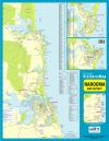
8.
Narooma & District
The Narooma & District Map extends from Moruya in the North to Bermagui in the South. Including detailed Street Maps of Bermagui, Dalmeny, Kianga, Narooma & Tuross Head.
District Map Scale 1: 110,000
Street Map Scale 1:20,000 & 1:25,000 |
|
|
9.
Wollondilly District
The Wollondilly District Map extends from Warragamba in the North to Yanderra in the South to Lake Burragorang in the West & Campbelltown in the East. Including detailed Street Maps of Appin, Bargo, Belimba Park, Buxton, Douglass Park, Menangle, Mount Hunter, Oakdale, Picton, Silverdale, Tahmoor, The Oaks, Thirlmere, Warragamba, Wilton & Yanderra.
District Map Scale 1:100,000
Street Map Scale 1:30,000 |
|
|
10.
Kiama & District
The Kiama & District Map extends from Albion Park, Bowral & Moss Vale in the North to Nowra in the South. Including detailed Street Maps of Gerringong, Gerroa, Jamberoo, Kiama, Minnamurra & Werri Beach.
District Map Scale 1: 160,000
Street Map Scale 1: 26,000 |
|
|
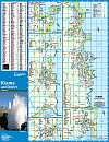
11.
Lakes Entrance & District 4nd Edition
The Lakes Entrance & District Map extends from Bruthen in the North to Loch Sport in the South, Nowa Nowa in the East and Meeriliew in the West.
Including detailed Street Maps of Lakes Entrance, Lake Tyers Beach, Bruthen & Metung
District Map Scale 1:140,000
Street Map Scale 1:15,000 |
|
|
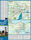
12.
Bairnsdale, Paynesville & District 3rd Edition
The Bairnsdale, Paynesville & District Map extends from Bruthen in the North to Loch Sport in the South, Nowa Nowa in the East and Meeriliew in the West.
Including detailed Street Maps of Bairnsdale, Bruthen & Paynesville
District Map Scale 1:140,000
Street Map Bairnsdale Scale 1:22,000
Street Map Paynseville Scale 1:24,000 |
|
|
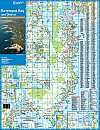
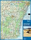
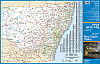
13.
South Coast & NSW
The South Coast Map extends from Sydney in the North and to Bairnsdale in the South.Including a detailed Map of New South Wales on the reverse. Region Map Scale 1:1,000,000
New South Wales Map Scale 1:2,500,000 |
|
|
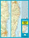
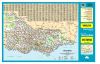
14.
North Coast & New South Wales 1st Edition
The North Coast Map extends from Brisbane in the North to Sydney in the South.Including a detailed Map of New South Wales on the reverse.
Region MapScale 1:750,000
New South Wales Map Scale 1:2,500,000 |
|
|
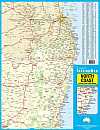
15.
North Coast 2nd Edition
The North Coast Map extends from Brisbane in the North to Wollongong in the South.
Including the New England Highway for tourists travelling the inland route
Scale 1:880,000 |
|
|
16.
New South Wales State Map
Scale 1:2,312,000 |
|
|
17.
Victoria State Map
Scale 1:1,540,000 |
|
|
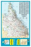
18.
Queensland State Map
Scale 1:4,032,000 |
|
|
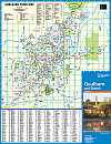
19.
Goulburn & District
|
|
|
| |
Your Basket
0 items in basket
|
|

