|
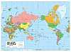
1.
World Political
Scally Gregory's World Political map. Size; 1227 x 915mm
Attractively coloured with bold and uncluttered information for educational uses.
Supplied laminated and with hang rails for use in library or classroom. |
|
|
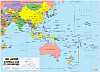
2.
Australia and its Neighbours
Scally Gregory's Australia and its Neighbours map. Size; 1280 x 920mm
Ideal for regional studies, countries are coloured and major cities are marked according to population. It focuses on Australia and countries to its north
Supplied laminated and with hang rails for educational uses.
Reverse side includes black line map suitable for use with whiteboard markers and A4 print suitable for classroom copies |
|
|
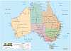
3.
Australia Political
Scally Gregory's Australia Political map. Size; 1270 x 920mm
A popular map with state boundariesa and states coloured with bold and uncluttered information for educational uses.
Supplied laminated and with hang rails for use in library or classroom. |
|
|
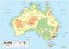
4.
Australia Physical
Scally Gregory's Australia Physical map. Size; 1270 x 920mm
Coloured to simply illustrate Australia's topography the information is presented clearly for educational purposes.
Supplied laminated and with hang rails for use in library or classroom. |
|
|
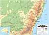
5.
New South Wales
Scally Gregory's New South Wales map. Size; 1280 x 920mm
Designed for detailed study of the state. A topographical map with all information clearly displayed and easy to read.
Supplied laminated and with hang rails for use in library or classroom. |
|
|
|
6.
World Political
Scally Gregory's World Political map. Size; 1227 x 915mm
Attractively coloured with bold and uncluttered information for educational uses.
Flat, laminated version only. |
|
|
|
7.
Australia and its Neighbours
Scally Gregory's Australia and its Neighbours map. Size; 1280 x 920mm
Ideal for regional studies, countries are coloured and major cities are marked according to population. It focuses on Australia and countries to its north
Flat, laminated version only.
Reverse side includes black line map suitable for use with whiteboard markers and A4 print suitable for classroom copies |
|
|
|
8.
Australia Political
Scally Gregory's Australia Political map. Size; 1270 x 920mm
A popular map with state boundariesa and states coloured with bold and uncluttered information for educational uses.
Flat, laminated version only. |
|
|
|
9.
Australia Physical
Scally Gregory's Australia Physical map. Size; 1270 x 920mm
Coloured to simply illustrate Australia's topography the information is presented clearly for educational purposes.
Flat, laminated version only. |
|
|
|
10.
New South Wales
Scally Gregory's New South Wales map. Size; 1280 x 920mm
Designed for detailed study of the state. A topographical map with all information clearly displayed and easy to read.
Flat, laminated version only. |
|

