|
1.
Batemans Bay & District 12th Edition
The Batemans Bay & District Map extends from Tabourie lake in the North to Moruya in the South.
Including detailed Street Maps of Batehaven,Broulee, Catalina, Denhams Beach, Durras, Durras Lake, Guerilla Bay, Lilli Pilli, Long Beach, Maloneys Beach, Malua Bay Mossy Point, Mogo,Moruya, Moruya Heads, Nelligen, Rosedale, Snshine Bay, Surf Beach & Rosedale.
District Map Scale 1:110,000
Street Map Scale 1:30,000 |
|
|
2.
Bairnsdale, Paynesville & District 3rd Edition
The Bairnsdale, Paynesville & District Map extends from Bruthen in the North to Loch Sport in the South, Nowa Nowa in the East and Meeriliew in the West.
Including detailed Street Maps of Bairnsdale, Bruthen & Paynesville
District Map Scale 1:140,000
Street Map Bairnsdale Scale 1:22,000
Street Map Paynseville Scale 1:24,000 |
|
|
3.
Blue Mountains National Parks
Craigies; Blue Mountains National Park Map covers the Blue Mountains, Kanangra-Boyd and Abercrombie River National Parks extending from Lidsdale in the north to Wombeyan Caves and Bargo in the south.
This very detailed map includes road, highways, road shields, suburbs and towns. Wilderness, forest and water catchment boundaries are also marked along with a handy grid for the 1:25 000 NSW topographic map coverage.
A very useful map for a complete overview of the Blue Mountains region it allows visitors to plan their journeys, with many fire trails and walking routes noted. The reverse side features detailed town maps of Blue Mountains townships including Blackheath, Medlow Bath, Katoomba, Leura, Wentworth Falls, BullaburraHazelbrook, Woodford, Faulconbridge, Springwood, Valley Heights, Warrimoo, Blaxland, Glenbrook, Mount Riverview and Lapstone.
Also included are mud maps for Blackheath, Katoomba, Leura and Wentworth Falls walking tracks noting lookouts, walking times and track grades.
National Parks Map Scale 1:130,000
Size (unfolded) 700 x 1000mm 1000 x 690mm |
|
|
4.
Goulburn & District 1st Edition
The Goulburn & District Map extends from Kanangra Tops in the North to Gunning in the South, Hanworth in the East and Crooked Corner in the West.
Including detailed Street Maps of Goulburn, Bradfordville, Crestwood, Eastgrove, Ilfield, Garfield, Goulburn South, Kenmore, Mummel, North Goulburn, Run-o-waters
District Map Scale 1:195,000
Street Map Goulburn Scale 1:20,000 |
|
|
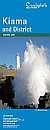
5.
Kiama & District 4th Edition
The Kiama & District Map extends from Helensburg in the North to Nowra in the South and Moss Vale in the West.
Including detailed Street Maps of Kiama, Berry, Gerringong, Gerroa, Shoalhaven Heads, Coolangatta, Kiama Heights, Bombo, Werri Beach, Jamberoo, Kiama Downs, Minnamurra
District Map Scale 1: 160,000
Street Map Scale 1: 26,000 |
|
|
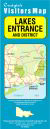
6.
Lakes Entrance & District 4nd Edition
The Lakes Entrance & District Map extends from Bruthen in the North to Loch Sport in the South, Nowa Nowa in the East and Meeriliew in the West.
Including detailed Street Maps of Lakes Entrance, Lake Tyers Beach, Bruthen & Metung
District Map Scale 1:140,000
Street Map Scale 1:15,000 |
|
|
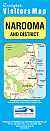
7.
Narooma & District 3rd Edition
The Narooma & District Map extends from Moruya in the North to Bermagui in the South. Including detailed Street Maps of Bermagui, Dalmeny, Kianga, Narooma & Tuross Head.
District Map Scale 1: 110,000
Street Map Scale 1:20,000 & 1:25,000 |
|
|
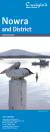
8.
Nowra & District 16th Edition
The Nowra & District Map extends from Gerringong & Kangaroo Valley in the North to Cudmirrah in the South & West to Morton National Park.
Including detailed Street Maps of Nowra & Bomaderry.
District Map Scale 1: 110,000
Street Map Scale 1:20,000 |
|
|
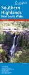
9.
Southern Highlands 15th Edition
The Southern Highlands map extends from Picton in the North to Nowra in the South & Marulan in the West. This edition has extended its coverage to include the new developments in Renwick
Incuding detailed Street Maps of Alymerton, Balaclava, Balmoral, Braemar, Berrima, Bong Bong, Bowral, Burradoo, Colo Vale, Mittagong, Moss Vale, Renwick & Willow Vale.
District Map Scale 1: 140,000
Street Map Scale 1:26,000 |
|
|
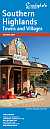
10.
Southern Highlands Towns & Villages 10th Edition
The Southern Highlands Towns & Villages Map is a supplement to the Southern Highlands Map.
Including detailed Street Maps of Aylmerton, Balaclava, Balmoral, Braemar, Bundanoon, Burrawang, Colo Vale, Exeter, Fitzroy Falls, Hill Top, Medway, New Berrima, Penrose, Robertson, Sutton Forest, Willow Vale, Wingello & Yerrinbool.
Street Map Scale 1:26,000 |
|
|
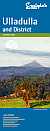
11.
Ulladulla & District 10th Edition
The Ulladulla & District Map extends from Wandandian in the North to Merry Beach in the South, Covering Morton National Park in the West. Including detailed Street Maps of Burrill Lake, Kings Point, Milton, Mollymook, Narrawallee & Ulladulla.
District Map Scale 1: 110,000
Street Map Scale 1;20,000 |
|

|
12.
Wollondily District 4th Edition
The Wollondilly District Map extends from Warragamba in the North to Yanderra in the South to Lake Burragorang in the West & Campbelltown in the East.
Including detailed Street Maps of Appin, Bargo, Belimba Park, Buxton, Douglas Park, Menangle, Mount Hunter, Oakdale, Picton, Silverdale, Tahmoor, The Oaks, Thirlmere, Warragamba, Wilton & Yanderra.
District Map Scale 1:100,000
Street Map Scale 1:30,000 |
|
|
| |
Your Basket
0 items in basket
|
|

